| Area | Sulphur Creek |
| Topic | Temperature: All Sulphur Creek Sub-basin Sites, MWAT by Year 2000-01 |
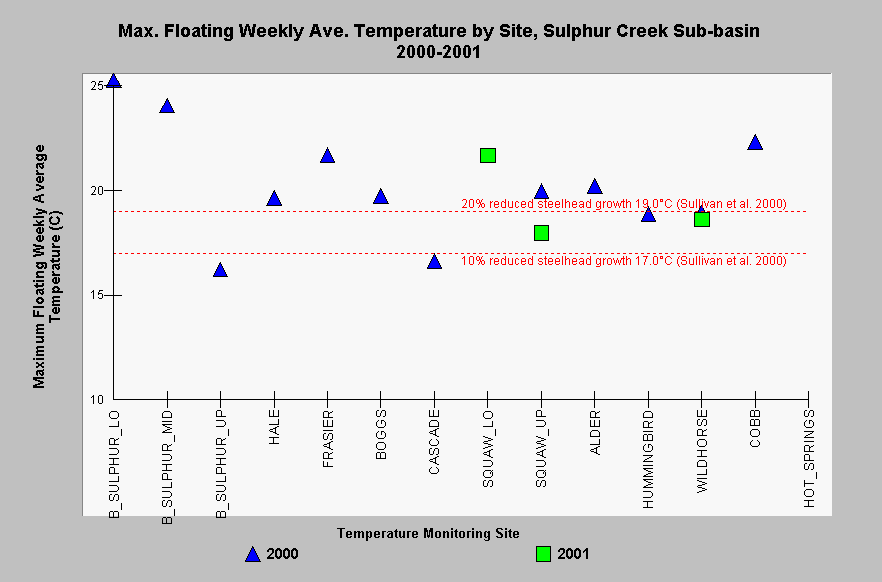
| Caption: This Chart shows maximum floating weekly average temperature (MWAT) for each site in the Sulphur Creek sub-basin with available data in the years 2000-2001. Sites are grouped by stream and are listed in upstream order, beginning on the left side of the chart with the lowest Big Sulphur Creek site and ending with Hot Springs Creek listed on the far right. MWATs exceeded 17.0°C at every site at least once at nine of twelve sites, and MWAT exceeded 19.0°C at least once at five of twelve sites. Based on a review of steelhead growth studies, Sullivan et al. (2000) found that compared to optimum temperatures, an MWAT of 17.0°C reduced steelhead growth by 10%, and an MWAT of 19.0°C reduced growth by 20%. See InfoLinks for more information. Data were collected by the California Department of Fish and Game and provided to KRIS by the Sonoma County Water Agency. | |
 |
To learn more about this topic click Info Links .
To view additional information (data source, aquisition date etc.) about this page, click Metadata .
To view the table with the chart's data, click Chart Table web page.
To download the table with the chart's data, click temp_rus_sc_mwatchart.dbf (size 5,710 bytes) .
To view the table with the chart's source data, click Source Table web page.
To download the table with the chart's source data, click temperature_proxy.dbf (size 80 bytes)
| www.krisweb.com |
