| Area |
Tomales Bay |
| Topic |
Land Cover: USFS Veg Size in Tomales Bay Riparian Zones 1994 |
|
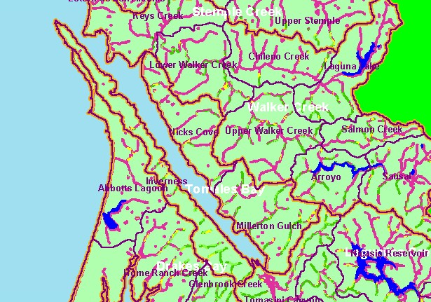
This is a map of 1994 USFS Landsat vegetation size data within 90-meter riparian buffer zones in the Tomales Bay sub-basin. Most
of the western basin extending out to the mouth of Tomales Bay and east of the bay is in grasslands, so streams have riparian zones
showing largely as Non-Forest. Riparian zones along creeks draining into Tomales Bay from the west near Inverness have forested
canopies. The vegetation classification is accurate at a one-hectare scale (approximately 11 pixels) and is suitable for stand
classification. Data provided by the U.S. Forest Service Spatial Analysis Lab in Sacramento, CA.
|
|
|
 |
 |
To view metadata about a map layer, click on a link in the table below.
| Name of Layer in Map Legend | Metadata File Name |
|---|
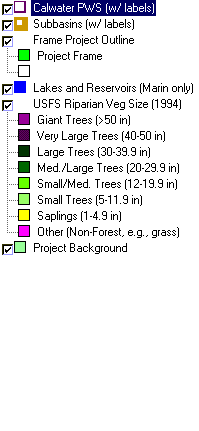
| Calwater PWS (w/ labels) | calw22.shp.txt |
| Subbasins (w/ labels) | subbasins.shp.txt |
| Frame Project Outline | Unavailable |
| Lakes and Reservoirs (Marin only) | Unavailable |
| USFS Riparian Veg Size (1994) | vegsizebuf.tif.txt |
| USFS Vegetation Size (1994) | vegsize.tif.txt |
| Topo Map, North (1:24k scale) | Unavailable |
| Topo Map, South (1:24k scale) | Unavailable |
| Project Background | Unavailable |