| Area |
Regional |
| Topic |
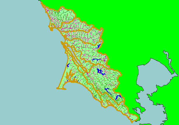
Map: 1J. USFS Riparian Vegetation Size, West Marin-Sonoma 1994 |
|
This is a map of 1994 USFS Landsat vegetation size data within 90-meter riparian buffer zones in the KRIS West Marin-Sonoma
Project Area. Not surprisingly, reaches of streams flowing through grasslands often have Non-Forest riparian zones. This may be
partially due to grazing and agricultural management practices. Data provided by the U.S. Forest Service Spatial Analysis Lab in
Sacramento, CA. The vegetation classification is accurate at a one-hectare scale (approximately 11 pixels) and is suitable for stand
classification.
|
|
|
 |
 |
To view metadata about a map layer, click on a link in the table below.
| Name of Layer in Map Legend | Metadata File Name |
|---|
| Subbasins (no labels) | subbasins.shp.txt |
| Frame Project Outline | Unavailable |
| Lakes and Reservoirs (Marin only) | Unavailable |
| USFS Riparian Veg Size (1994) | vegsizebuf.tif.txt |
| USFS Vegetation Size (1994) | vegsize.tif.txt |
| Topo Map, North (1:24k scale) | Unavailable |
| Topo Map, South (1:24k scale) | Unavailable |
| Project Background | Unavailable |